It's a New Day in Public Health.
The Florida Department of Health works to protect, promote, and improve the health of all people in Florida through integrated state, county, and community efforts.
Florida Water Management Inventory Details
Contact the Inventory Team
- 850-245-4250
- DCEHInventory@flhealth.gov
-
Fax
850-487-0864
Project Status
The project began in April 2014. The initial mapping and summary were complete for all Florida counties in September 2016. The Final Report for this first phase is publicly available. Another round of data gathering was initiated in December 2016 and the mapping was updated throughout 2017 and 2018. Data for these first two phases are available on the project ftp site.
The current phase of the project seeks to continue filling in data gaps, collecting data for properties served by public water systems and wastewater systems, and expanding the information for domestic private wells and onsite septic systems.
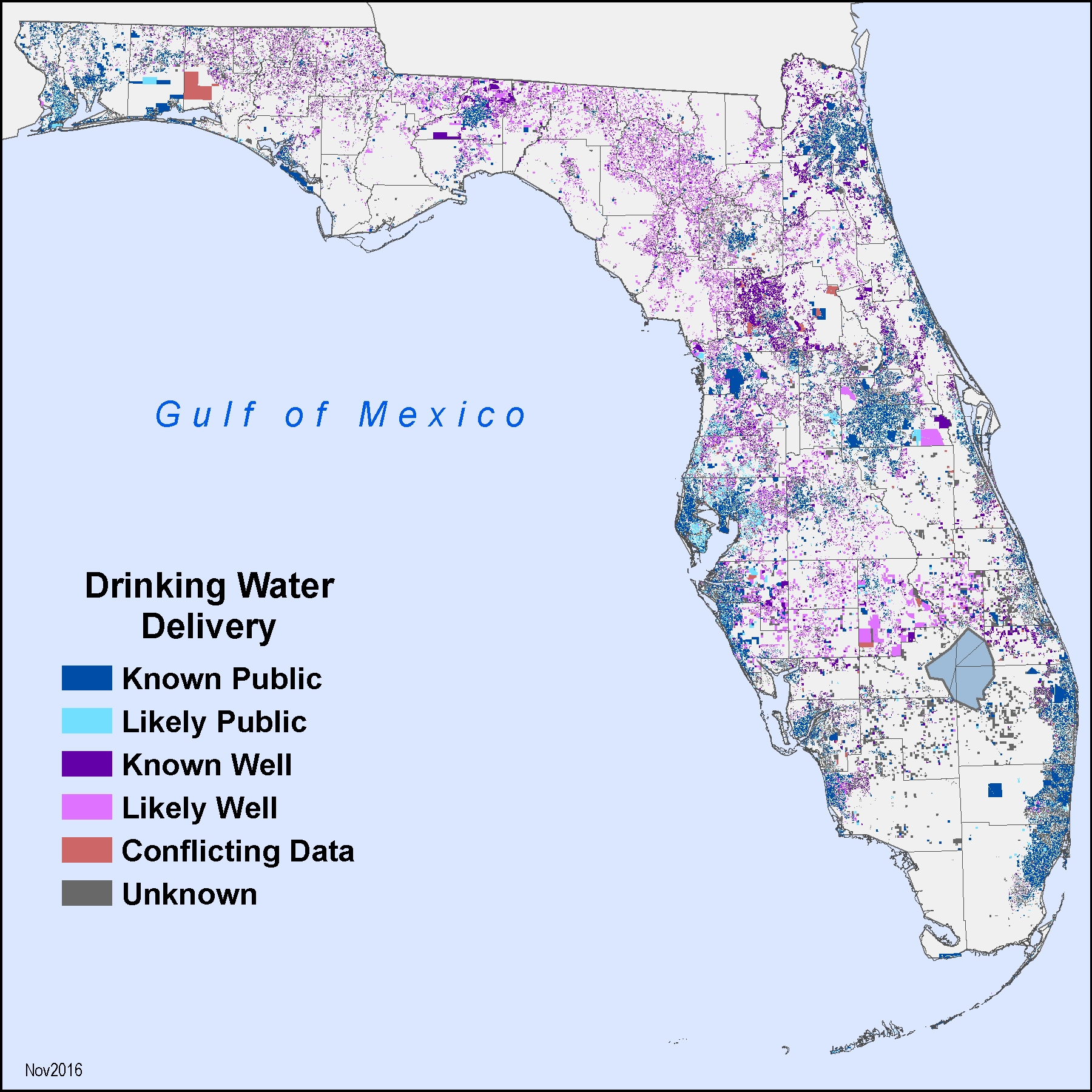
Drinking Water Sources by Property in Florida
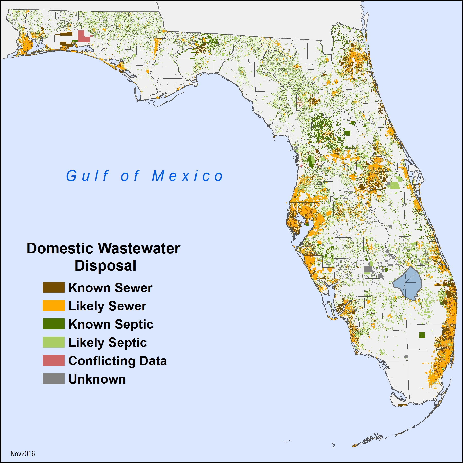
Wastewater Disposal Methods by Property in Florida
Data Gathering
Requested Data Sets
Data Fields and Formats
Knowing What to Submit in Your Data Set
Submitting Your Data Set to the Project Team
We are seeking information on property parcels and/or physical service addresses served by each Wastewater Treatment Facility (WWTF) and Public Water System (PWS) in the state that are permitted by the Florida Department of Environmental Protection (FDEP). We have already obtained information regarding the specific WWTF and PWS facilities from FDEP. What we do not have and the information we are requesting is which property parcels and/or physical addresses are connnected to each permitted facility. The obtained information provides public and private entities a quick view of both drinking water and wastewater utilities that service each developed parcel/property address.
It is important to note that, for the purpose of the Florida Water Management Inventory, any facility that is permitted by FDEP is considered to be “public” (i.e. Central Sewer and/or Public Water), regardless of ownership, capacity or how many parcels are served by the facility.
Geographic Information System (GIS) datasets are the preferred type of data to be obtained. Esri data formats (geodatabases, shapefiles) are easiest for us to import, but other formats such as kml or dwg may also be provided. Examples of the types of GIS feature layers that were previously provided are:
- Parcel polygons with attributes for ParcelNo, physical address, wastewater method, drinking water source, WWTF ID, PWS ID
- Potable water, central sewer or combined service address points with attributes for ParcelNo, physical address, wastewater method, drinking water source, WWTF ID, PWS ID
- Meter location points with attributes for type of service, number of connections, active status
- Potable water or central sewer service laterals and mains
- Service Area or Franchise boundaries
We recognize that not all organizations will have access to GIS data sets. Accordingly, if GIS files are not available, we can also accept property parcel and/or service address information in other formats, such as:
- Database tables from MS SQL Server, MS Access, or other database systems
- Comma Delimited (CSV) spreadsheet files
- The MS Excel spreadsheet template developed by the Project Team for data gathering
The Project Team requests all data in an electronic format. Regrettably, we cannot accept handwritten, photocopied, faxed, and other paper documents.
The required data fields for each property parcel and/or service address should include the following.
- Property Parcel ID / Tax ID
- Physical Address (street address, city, zip code)
- County
- Drinking Water Source (Public Water, Private Well, Limited Use Well Known)
- Facility ID (as permitted by FDEP) & Name of the PWS providing water to the property, if applicable
- Wastewater Method (Sewer, Septic, Unknown)
- Facility ID (as permitted by FDEP) & Name of the WWTF providing sewer service to the property if applicable
- Comments (relevant to the particular property or facility to which the data refers)
Each of the fields above should be included in the data sets submitted to the Project Team, whether they are GIS files, database table extracts, or the MS Excel spreadsheet template developed by the Project Team. Please include the date submitted.
Knowing What to Submit in Your Data Set
We request both Parcel ID (or Tax ID) and the service address for each property served by your facility. The Parcel ID may be obtained from your tax bill or the local Property Appraiser’s office. The basis of the inventory are GIS datasets of parcels received from the Florida Department of Revenue (DOR). Every parcel has an associated parcel ID. We match the Parcel ID provided by the utility to the Parcel ID for our GIS data as part of the import process, but we have found that this ID may be formatted differently between the Property Appraiser and DOR. Therefore, the physical addresses are also requested.
If the permitted WWTF or PWS facility for which you are reporting provides sewer and/or water only to one property parcel (i.e. Mobile Home or RV Park, small commercial building, municipal park), you may respond by email, indicating that this is a Single Parcel Facility, and please include the Drinking Water source (Public, Private Well, or Limited Use Well) and the Wastewater method (Sewer or Septic).
If the facility(s) for which you are reporting serves multiple parcels, then there would be multiple corresponding records (or rows). If the facility(s) for which you are reporting serves many property parcels and/or service addresses (dozens, hundreds, or thousands), you would, most likely, be submitting a data set containing a list of all the customer addresses served by your facility(s). We are not, however, looking for customer names or other personally identifiable information.
Submitting Your Data Set to the Project Team
All data sets are requested as digital files transmitted electronically. There are multiple options available for you to submit your data sets. Note: Under Florida law, e-mail addresses are public records. If you do not want your e-mail address released in response to a public-records request, do not send electronic mail to this agency. Instead contact the office or individual by phone or in writing.
- You may simply attach and email your files less than 8MB
- You may utilize the Florida Department of Health (FDOH) MOVEit DMZ secure messaging system** for files larger than 8MB
- You may email the Project Team the location of files available on your public Internet website
- You may place the files on your File Transfer Protocol (FTP) site and email the Project Team with the link and any required credentials for accessing the files
Under Florida law, e-mail addresses are public records. If you do not want your e-mail address released in response to a public-records request, do not send electronic mail to this agency. Instead contact the office or individual by phone or in writing.Email the Water and Onsite Sewage Program Inventory Team with any questions or comments.
Note: This page contains materials in the Portable Document Format (PDF). The free Adobe Reader may be required to view these files. This page also contains Excel spreadesheets. The free Microsoft Excel viewer may be required to view these files.

Connect with DOH